Bloody Battle of Peleliu: New Japanese Defensive Tactics
On September 15, 1944, the Battle of Peleliu, known as Operation Stalemate II, began. Being part of a large campaign to capture the Mariana Islands, this battle, according to the head of the operation, Major General William Rupertus, should have ended in success in four days. In reality, the battle for the tiny (about ten kilometers long and about one and a half kilometers wide) island lasted for two months and became one of the bloodiest battles of the entire campaign. Why did the previously successful American “island racing” fail?
Asymmetrical defense
The answer is simple. The Japanese command finally drew the right conclusions from the enemy’s basic tactics and stopped fighting the American troops on their terms. Instead of fighting on the beach, in fact, in an open field, and even under fire from the sea and continuous air raids by American attack aircraft, the Japanese moved their defensive positions inland.
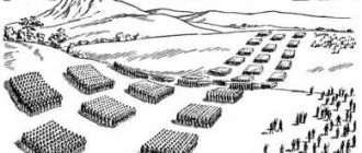
The difficult terrain of the island was very convenient for long-term defense. Colonel Kunio Nakagawa hid his 11,000-man garrison in bunkers and permanent gun emplacements. A system of bunkers with a “cellular” layout made it possible to quietly transfer forces along protected passages and effectively counteract an enemy offensive. About five hundred natural caves and quarries in Mount Umurbrogol became the basis of the Japanese fortress on Peleliu. Sliding armored flaps, camouflage and simple engineering equipment further strengthened the former quarries.
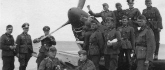
A typical long-term firing point of a Japanese garrison
Indirect mortars, including large-caliber ones, high-velocity anti-aircraft guns, 47 mm anti-tank guns and light tanks became the mainstay of support for the Japanese garrison. There was no longer talk of any “banzai attacks”. The Japanese command was no longer going to overwhelm the enemy with meat, as had happened more than once in the past. Even the soldiers allocated for the initial defense of the beach were required not so much to “die with honor” as to delay and disorganize the landing, and then retreat to reserve positions.
A three-day naval bombardment of the island with main-caliber shells from battleships (410 mm and 360 mm) and cruisers (203 mm), with breaks for aerial bombardment with 500-pound bombs, ended in almost the same mess as the multi-day shelling of the First World War. Impressive columns of sand and smoke rose above the island - but even the beach defense battalion, with its temporary simple shelters, suffered almost no real losses. Firing at a dispersed and well-covered enemy without coordination of fire by artillery observers “on the ground” again showed its costly inadequacy.
However, the Japanese airfield with all its buildings, all airfield equipment and aircraft ceased to exist as a result of the shelling in an extremely spectacular and convincing manner.
The fruits of the new defensive tactics
The initial stage of the landing of American troops took place according to a proven pattern. Naval sappers removed a large number of obstacles and explosive devices from heavy artillery shells, which revealed the main landing zones to the Japanese - but the Japanese garrison was in no hurry to demonstrate this knowledge to the enemy.
The first wave of landing. Note the cover of naval artillery with a barrage of fire.
The usual routine was disrupted at the moment when the LVT and DUKW amphibious assault vehicles found themselves in the garrison’s firing sectors. Covered for the time being with armored barriers and well-camouflaged 47-mm guns, 20-mm rapid-fire cannons and machine guns hit the flank of the amphibians, protected only by anti-fragmentation armor, beginning a bountiful bloody harvest. Within an hour from the moment of landing, the total number of irretrievable losses reached 60 vehicles.
Marine Colonel Chesty Puller survived only because the shell that penetrated his amphibian did not explode. His signalmen were killed in full when a 47-mm shell hit their car. It was no longer possible to quickly restore control over his subordinates. The difficult terrain of the landing site did not allow landing on a wide front. The amphibians stretched out in a column, as well as small “pockets” of landing sites, were under constant fire.
However, the landing continued. The coconut grove allowed the Marines to reach almost the ruins of the airfield, plowed up by naval fire, where they were met by a counterattack by Japanese infantry and light tanks. Initially successful, it predictably choked, encountering joint opposition from naval and ground artillery, aerial bombardment, and American tanks that finally reached the battlefield.
At the end of the day, having lost about 200 killed and 900 wounded, the landing party controlled the landing bridgeheads - and nothing more. At the same time, the commander of the operation, Major General Rupertus, was fully confident that he had broken through the enemy perimeter, and any Japanese defense would inevitably crumble in the coming days.
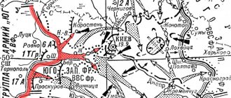
Modern battle map for Peleliu
One glance at the map is enough to see how wrong he was. The untaken southern cape and artillery positions in the center of the island created an extremely effective fire bag for any active actions of the American landing force.
Running under fire
The second day of fighting and the re-movement of American units to the airfield took place under conditions of continuous shelling. It was a hot day in every way. The temperature of 46 degrees made a significant contribution to the total number of losses. The situation was further aggravated by the supplies - the enemy’s long-term fortifications, which had not yet been suppressed, did not allow the personnel to be properly provided with even the most necessary supplies. Drinking water often had to be delivered to positions in empty fuel barrels, not only disgustingly warm, but also with a completely predictable bouquet of unique fuel and lubricant tastes and aromas.
An American Marine brings a flask of water to a wounded comrade.
Although by the end of the day the airfield was under the control of the paratroopers, Japanese fire from Mount Umurbrogol prevented its use. Only on September 26, almost two weeks after the landing, was the airfield able to accept anything larger than a reconnaissance aircraft. The Americans were able to use F4U Corsairs to attack Japanese positions. It was worth it - now the Japanese garrison had to operate under fire, and in the literal sense of the word - the “Corsairs” of the Peleliu airfield became the second active carriers of aircraft napalm bombs in the history of this subtype of weapons.
An F4U corsair drops a container of napalm during an assault mission.
As a rule, the burnt-out air at the site where the container fell and the fluidity of napalm ensured that even a seemingly combat-ready Japanese garrison was no longer left after the attack.
The location of the airfield almost close to the beginning of the main network of Japanese fortifications on Umurbrogol created an amusing incident - it took more time to take off and form up than to approach the target. We were talking about an arrival time of less than one minute. Some pilots didn’t even spend time retracting the landing gear. This made it possible to bomb the enemy at virtually the same speed as ground-based gunsmiths working to deliver and secure new ammunition under the wings of the aircraft. But even in such conditions, the departure from old tactics allowed the Japanese garrison to stretch out resistance for a long time.
Battle on the Southern Cape
The Japanese fortifications on the southern cape were stormed by one of the marine units, which was pretty battered during the landing and even lacked machine guns. The battle lasted for more than a day. For most of this time, for the Marines, he was surrounded. A “layer cake” was organized at the positions, the sight of which would have made even a veteran of the trench battles of the First World War shudder.
American Marines in individual shelters
Smoke grenades made it possible to storm the machine gun nests one at a time, after which the Marines approached the cannon bunker and, with a successful grenade throw, set fire to its ammunition. According to eyewitnesses, at the moment of the destruction of the bunker, personal portable ammunition exploded with a crash on the burning soldiers of the Japanese garrison.
There are never too many grenades in such battles.
Four successive Japanese counterattacks meant that, in the end, the few survivors of the assault on the Japanese position fought back hand-to-hand. Only 18 fighters from the original composition of the unit retained their combat effectiveness. One hundred fifty-seven died in battle.
Ridge of a Broken Nose
Episodes of fighting for long-term defensive positions near Mount Umurbrogol turned into a series of almost ineffective and very bloody offensives under flanking crossfire.
The balance of forces at the time of the start of the assault on the main positions on Mount Umurbrogol. Drawing from the unit's report
The Japanese garrison showed unprecedented restraint. The fire was not conducted from the moment the enemy met, but only after most of the targets were drawn under guaranteed fire cover from Japanese riflemen without the possibility of easy retreat.
A sniper warning sign made from the skull of a Japanese soldier. Typical evidence of mutual bitterness
There were also frequent cases of war crimes on the part of the Japanese - snipers deliberately fired at orderlies, as new ones appeared to replace the wounded and killed orderlies - and this made it possible to kill more often and with less effort. Night forays of Japanese saboteurs behind the front line led to the fact that individual cells had to be dug in double units - while one soldier was sleeping, the second, next to him, was on guard.
There were also cases of incorrect assessment of the combat situation by American mid-level command. Captain Everett Pope drove 90 of his subordinates into encirclement, where they had to fight back in the end with literally knives, stones and empty ammunition boxes. At the time of leaving the position, only 9 people remained at his disposal. Major Raymond Davis lost 70% of the soldiers entrusted to him in six days of fighting.
Attempts to change the situation with new landings from the sea only led to the landing landing at the bottom of Umurbrogol - with the same result as any offensive by land. By the beginning of October, offensive tactics had finally turned into engineering tactics. Bulldozer and flamethrower tanks became the basis for clearing fortifications. But even with their use, the cleanup took a long time.
It was not until November 24 that Colonel Nakagawa was forced to admit that “ our sword is broken, our spears are gone.”
“—after which he demonstratively burned the unit’s banner and committed ritual suicide. The Japanese high command awarded him the posthumous rank of lieutenant general for his valor.
On November 27, 1944, the 73-day battle officially ended. However, as often happens in the Pacific theater, it is not for everyone. Lieutenant Ei Yamaguchi and 33 of his men hid until the end of March 1947, after which they attacked the local US Marine garrison. Only a Japanese admiral, rushed to the island (along with additional American Marines), convinced them to stop the senseless bloodshed.
The final stage of the operation. Drawing from the unit's report
Work on mistakes
At the cost of approximately three thousand killed and twelve thousand wounded, the new Japanese defensive tactics ceased to be a military secret. The Japanese side traditionally lost about one hundred percent of its personnel - as a result of the battles, 183 Korean workers and 19 Japanese soldiers from a garrison of 11,000 people were captured. The First US Marine Division lost a total of about a third of its personnel killed and wounded - more than 6,500 people. Before the invasion of Okinawa on April 1, 1945, she was under replenishment and did not take part in hostilities.
The high casualties and low significance of the isolated Japanese garrison, deprived of supplies from outside, often led to intense debate as to whether the operation was justified at all. Meanwhile, in these disputes, what is usually overlooked is that it was the battles for Peleliu and the battle for tiny Angaur, which took place around the same time, that demonstrated a change in tactics by the Japanese side at the right time. By and large, it was these bloody landings on “useless” islands that made it possible to begin work on effective counteraction in advance, and not directly during a major landing operation.
The subsequent battles for Iwo Jima and Okinawa clearly demonstrated the cost of such a mistake.
Sources:
- United States army in World War II: The war against Japan. Center of military history United States army. Washington DC, 2001
- Peleliu 1944, Oxford: Osprey publishing
- Operation Stalemate II, Lt Col Daniel C. Hodges, Fort Leavenworth, Kansas.
- Operation report 81st Infantry, Peleliu, 23 Sept. — 27 Nov. 1944
- Japanese military caves on Peleliu: know your Enemy! (US Navy, 1945)
Geography[edit]
Peleliu World War II Memorial Museum
Peleliu is located approximately 10 km northeast of Angaur Island and 40 km southwest of Koror Island. Peleliu has a total area of 13 square kilometers (5.0 sq mi; 3,200 acres). As of 2000, [Update]its population was approximately 571, making it the third most populous state in Palau. [4] Most of the island's population lives in the village of Cloulclubed, which is the state capital on the northwest coast. Including the capital, there are only four villages:
- Kloulclubed (northwest)
- Imelechol (northeast)
- Lademisang (the southernmost, in the central part of the island)
- Ongeuidel (northernmost)
Islands of the state[edit]
The state consists of the following islands:
| Island | Area (km²) | Population (2000) | Coordinates |
| Peleliu | 12,8 | 571 | 07°00'44.65″N, 134°15'01.24″E / 7.0124028 ° N W. 134.2503444 ° E / 7.0124028; 134.2503444 |
| Ngercheu | 0,93 | 0 | 07°05'33.51″N, 134°16'41.12″E / 7.0926417°N 134.2780889°E / 7.0926417; 134.2780889 |
| Ngezebus | 0,95 | 0 | 07°03'23.92″N, 134°15'35.94″E / 7.0566444°N 134.2599833°E / 7.0566444; 134.2599833 |
| Ngurungor | 0,54 | 0 | 07°01'16.39″N, 134°16'20.731″E / 7.0212194°N 134.27242528°E / 7.0212194; 134.27242528 |
| Kongauru | 0,34 | 0 | 07°03'47.92″N, 134°16'26.14″E / 7.0633111°N 134.2739278°E / 7.0633111; 134.2739278 |
| Murphy Island | 0,02 | 0 | 07°03'54.97″N, 134°16'56.75″E / 7.0652694°N 134.2824306°E / 7.0652694; 134.2824306 |
Links[edit]
- Burney, James A Chronological History of the Discoveries in the South Sea or Pacific Ocean
, London, 1813, vI, p. 233. - Coelho, Francisco "Conflicto hispano-alemán" Boletín de Sociedad Geográfica de Madrid
, vol. XIX. 2nd semester 1885, Madrid, p.296. - Events Calendar Archived 2015-01-21 in the Wayback Machine - Palau VTS. Retrieved January 21, 2015.
- Patterson, Caroline Bennett, et al. "At the Birth of Nations: In the Far Pacific."
National Geographic Magazine, October 1986, p. 493. National Geographic Virtual Library, accessed May 17, 2022. “An example is Peleliu, the tragic island where more than 13,000 Americans and Japanese died in less than three months of fighting , often hand-to-hand. autumn 1944. Pat and I traveled to Peleliu from Koror, the capital of the republic, by speedboat, bouncing waves and bouncing backs for 45 minutes, and arrived to find that it was election day and five candidates were running for governor. claims a population of 2,000, of which only 400 actually live. More registered voters live in Koror than on their home island, and 800 vote from Guam. The situation is similar in other states of Palau." - "Peleliu". BirdLife Data Zone
. BirdLife International. 2022. Retrieved March 5, 2022. - "Northern Peleliu Lkes (sand plains)". BirdLife Data Zone
. BirdLife International. 2022. Retrieved March 6, 2022. - "State/National Election Schedule". Electoral Commission of Palau
. November 5, 2022. - "National Registry Information System". National Register of Historic Places
. National Park Service. July 9, 2010 - "National Registry Information System". National Register of Historic Places
. National Park Service. March 13, 2009 - "Peleliu Elementary School Archived 2017-10-05 at the Wayback Machine." Ministry of Education (Palau). Retrieved February 22, 2018.
- "archived March 3, 2022 on the Wayback Machine." Palau High School. Retrieved February 22, 2022.
Environment[edit]
Both IBAs are important for Micronesian megapodes.
Important bird areas[edit]
BirdLife International has declared the island an Important Bird Area (IBA) as it supports populations of most of Palau's endemic birds, including Micronesian megapodes, Palau ground pigeons, Micronesian imperial pigeons, Palauan fruit pigeons, swiftlets, owls and kingfishers, Micronesian mysomelas, morningbirds, Palauan curlytails, flycatchers and warblers, giant, dusky and citrine white-eyes, and Micronesian starlings. [5]
The sand flats, mangroves, kelp beds and islets near the northern tip of Peleliu provide feeding and roosting habitat for a variety of shorebird species, and are also home to megapodes. The site provides an IBA for megapods, Far Eastern curlews, ruddy turnstones, great knots, red-necked grasshoppers and grey-tailed babblers. [6]
Infrastructure[edit]
Peleliu Airfield, established by the Japanese during World War II, has the longest and widest runway in Palau (1,850 meters (6,070 ft)), but was only used by small chartered aircraft after Palau's domestic flights ceased in late 2005 . The boat runs between the island twice a week with Koror and Angaur. The boat journey from Koror is over an hour. The small harbor in the far north of the island is shallow and suitable only for shallow-draft yachts.
Peleliu Battlefield[edit]
United States historic place
| Peleliu Battlefield | |
| US National Register of Historic Places | |
| US National Historic Landmark | |
| Location | Peleliu, Palau |
| Region | 7,680 acres (3,110 ha) |
| Built | 1944 |
| NRHP reference no. | 85001754 [8] |
| Added to NRHP | February 4, 1985 |
The entire island was listed on the National Register of Historic Places as the Peleliu Battlefield
and is designated a US National Historic Landmark. [9]